Homemade Paris walking metro map! Soon official? @GroupeRATP @tfl @transportshaker HD => https://t.co/eTl3fUya9J pic.twitter.com/pY1XNX3S0f
— Guillaume MARTINETTI (@gmartinetti84) November 29, 2015
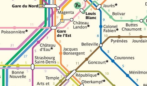
He said that he used information from Paris transport chiefs RATP together with the Google Maps walking predictor function to make the map, a high definition version of which can be seen here, all based on the assumption that the walker is moving at a pace of 4.5km/hr.
He found that some stations are just three minutes' walk from each other – such as République to Temple, and even Temple to Arts et Métiers.
The map follows hot on the footsteps of a similar map of the London underground, which was rolled out by London transport authorities last month.
If you find yourself with some extra time thanks to walking around Paris rather than being stuck on the Metro, why not try your hand at these (increasingly difficult) Metro station word puzzles created by The Local. Good luck!
(Click the map below to see a higher resolution with zoom options)

Member comments